In the ever-evolving landscape of aerial videography, the integration of photogrammetry with drones has emerged as a game-changer, offering a plethora of benefits to businesses in the field. From enhanced efficiency to unparalleled precision, this innovative technology has revolutionized the way aerial video projects are approached and executed.
-
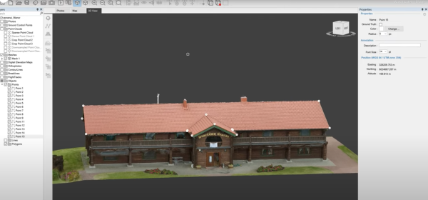
Precision and Accuracy: Photogrammetry, coupled with drones, allows for the creation of highly detailed 3D models and maps with remarkable precision. By capturing a series of overlapping images from different angles, drones can collect data that is then processed through photogrammetry software to generate accurate models of terrain, structures, or objects. This level of precision is invaluable for various industries, including construction, agriculture, and urban planning, where detailed spatial information is crucial for decision-making.
-
Cost-Effectiveness: Traditionally, acquiring aerial imagery for mapping or modeling purposes required expensive manned aircraft or satellite imagery. Drones equipped with photogrammetry capabilities offer a cost-effective alternative, significantly reducing the overhead costs associated with aerial data acquisition. This accessibility democratizes the use of high-resolution imagery and 3D modeling, making it feasible for businesses of all sizes to leverage the power of aerial data.
-
Efficiency and Time-Saving: The efficiency gains facilitated by drone-based photogrammetry are substantial. Drones can cover large areas in a fraction of the time it would take traditional methods, accelerating project timelines and reducing labor costs. Furthermore, the rapid turnaround time in processing data means that stakeholders can access actionable insights and visualizations much quicker, enabling faster decision-making and project implementation.
-
Enhanced Safety: One of the most significant advantages of utilizing drones for aerial videography and photogrammetry is the enhanced safety they provide. By eliminating the need for human operators to access hazardous or hard-to-reach areas, drones mitigate risks associated with traditional data collection methods. This is particularly beneficial in industries such as mining, infrastructure inspection, and disaster response, where safety is paramount.
-
Versatility and Adaptability: Drones equipped with photogrammetry capabilities are incredibly versatile and can be customized to suit a wide range of applications. Whether it's monitoring crop health, surveying construction sites, or creating virtual tours of real estate properties, the possibilities are endless. Moreover, drones can easily adapt to changing project requirements, offering flexibility and scalability that traditional methods often lack.